Wednesday, April 30, 2014

The Daily Drift

Editorial Comment: The severe weather skipped by us yesterday. However today is supposed to have been the worse of the two so it remains to be seen if Ma Nature knocks us off the net for a spell. The air was so wet yesterday that you needed scuba gear to breathe outside but nothing fell from the clouds. Today is an entirely different story.
Beltane (aka: Beltaine) is today. Celebrate Spring ...!
 
Carolina Naturally is read in 197 countries around the world daily.   

Bugs  ... !
Today is - Bugs Bunny Day


Don't forget to visit our sister blog: It Is What It Is

Some of our reader today have been in:
The Americas
Leeds, Kalispell, Venice, Pasco, Baraboo and Palatine, United States
Toronto, Sioux Lookout, Ottawa, Pikangikum, Thunder Bay, Montreal, Mississauga and Britannia, Canada
Curitiba and Sao Paulo, Brazil
Tijuana, Mexicali and Mexico City, Mexico
Buenos Aires, Argentina
Managua, Nicaragua
Bogota, Colombia
Europe
Kiev and Kharkiv, Ukraine
Vienna, Austria
Widdern, Konstanz, Koeln, Dusseldorf and Neuss, Germany
Rouen, Magenta, Paris, Oberhaslach and Salon-De-Provence, France
Pescara and Capriate San Gervasio, Italy
Zurich, Switzerland
Bucharest, Romania
Manchester, London, Exeter and Euston, England
Dubrovnik, Croatia
Madrid and Ferrol, Spain
Reykjavik, Iceland
Izmir, Turkey
Sarajevo, Bosnia and Herzegovina
Oslo, Norway
Dublin, Ireland
Vladivostok, Ryazan and Domodedovo, Russia
Brussels, Belgium
Bratislava, Slovakia
Stockholm, Sweden
Lisbon, Portugal
Copenhagen and Kongens Lyngby, Denmark
Asia
Cuttack, Thiruvananthpuram, New Delhi, Bangalore, Pune, Ahmedabad and Mumbai, India
Jakarta, Indonesia
Colombo and Galkissa, Sri Lanka
Hanoi, Vietnam
Beijing, Xi'an, China
La Dagotiere, Mauritius
Tokyo, Japan
Kuala Lumpur, Lahad Datu and Putrajaya, Malaysia
Bangkok and Lat Krabang, Thailand
Amman, Jordan
Beirut, Lebanon
Tehran and Esfahan, Iran
Kathmandu, Nepal
Africa 
Casablanca, Morocco
Cairo, Egypt
Cape Town, South Africa
Shurugwi, Zimbabwe
Bahan, Sudan
The Pacific
Sydney, Australia
Makati and Manila, Philippines

Today in History

313 Licinius unifies the whole of the eastern Roman Empire under his own rule.
1250 King Louis IX of France is ransomed.
1527 Henry VIII of England and King Francis of France sign treaty of Westminster.
1563 All Jews are expelled from France by order of Charles VI.
1725 Spain withdraws from the Quadruple Alliance.
1789 George Washington is inaugurated as the first U.S. president.
1803 The United States doubles in size through the Louisiana Purchase, which was sold by France for $15 million.
1812 Louisiana is admitted into the Union as a state.
1849 Giuseppe Garabaldi, the Italian patriot and guerrilla leader, repulses a French attack on Rome.
1864 Work begins on the Dams along the Red River, which will allow Union General Nathaniel Banks' troops to sail over the rapids above Alexandria, Louisiana.
1930 The Soviet Union proposes a military alliance with France and Great Britain.
1931 The George Washington Bridge, linking New York City and New Jersey, opens.
1943 The British submarine HMS Seraph drops 'the man who never was,' a dead man the British planted with false invasion plans, into the Mediterranean off the coast of Spain.
1945 Adolf Hitler commits suicide in his bunker. Karl Donitz becomes his successor.
1968 U.S. Marines attack a division of North Vietnamese troops in the village of Dai Do.
1970 U.S. troops invade Cambodia to disrupt North Vietnamese Army base areas.
1972 The North Vietnamese launch an invasion of the South.
1973 Nixon announces the resignation of H.R. Haldeman, John Ehrlichman, and other top aides.
1975 North Vietnamese troops enter the Independence Palace of South Vietnam in Saigon ending the Vietnam War.
1980 Terrorists seize the Iranian Embassy in London.

An ecologist imagines the world's end

Paul Kingsnorth is an English writer whose environmental activism got him jailed in the 90s and praised by the archbishop of Canterbury and the Prime Minister in the 00s. His Dark Mountain Project, founded in 2009, is an outdoor festival for artists and writers, described this weekend in The New York Times' profile.
In the clearing, above a pyre, someone had erected a tall wicker sculpture in the shape of a tree, with dense gnarls and hanging hoops. Four men in masks knelt at the sculpture’s base, at cardinal compass points. When midnight struck, a fifth man, his head shaved smooth and wearing a kimono, began to walk slowly around them. As he passed the masked figures, each ignited a yellow flare, until finally, his circuit complete, the bald man set the sculpture on fire. For a couple of minutes, it was quiet. Then as the wicker blazed, a soft chant passed through the crowd, the words only gradually becoming clear: “We are gathered. We are gathered. We are gathered.” After that came disorder. A man wearing a stag mask bounded into the clearing and shouted: “Come! Let’s play!” The crowd broke up. Some headed for bed. A majority headed for the woods, to a makeshift stage that had been blocked off with hay bales and covered by an enormous nylon parachute. There they danced, sang, laughed, barked, growled, hooted, mooed, bleated and meowed, forming a kind of atavistic, improvisatory choir.
This is actually a pretty normal weekend for Worthing, England, but I digress. The story here is the unsettling quality of his manifesto, Uncivilization, which hammers at the "false hope" of much said in the name of environmentalism--a darker, doomier view of our ecological future that is, to some, a betrayal, a "troubling abdication." It has a counterpart in fiction: Kingsorth's novel, The Wake, is a "postapocalyptic tale set 1000 years ago", after the Norman invasion, composed in a hybrid of modern and old English.


'False Springs' May Become Thing of the Past

Chilly interruptions of spring revelry may someday disappear as the planet warms.

The Kannesteinen Rock

Shaped over thousands of years by the crashing waves, the Kannesteinen Rock is a magnificent mushroom shaped rock formation located in the rural village of Oppedal, Norway.

While difficult to measure the exact size by looking at the photographs, the rock is about three feet high and wide enough for three or four people to stand on.

The Beheaded Statues Of Nemrut Dagi in Turkey

Nemrut Dagi is a mountain in southeastern Turkey, notable for the summit where a number of large statues are erected around what is assumed to be a royal tomb.

Decapitated statues are sitting with their heads on the ground watching around south-eastern Turkey on top of one of the highest peaks of the Eastern Taurus mountain range. The archaeological site Nemrut Dagi is a time machine on top of a mountain that'll take you back to 62BCE

Laze Around The Isolated Beaches Of Dhermi, Albania

In a not-so popular and rather mysterious Albania, a line of coastline villages, also called the Albanian Riviera, possesses isolated sand and pebble beaches with pristine and crystal clear waters. Dhermi is a local fave and a must-see for travelers who're looking for a valuable spot with an expensive-looking scenery.

Picture This ...

Check out a snapshot of remarkable moments from around the world.

U.S. Route 50

America's Loneliest Road

U.S. Route 50 is a major east–west highway, connecting Ocean City, Maryland and West Sacramento, California. Stretching 3,000 miles (4,800 km), the route runs through mostly rural areas in the Western part of the US.

It includes the section through Nevada known as 'The Loneliest Road in America.'

The World's Longest Conveyor Belt Is 61 Miles Long

Western Sahara, a territory currently ruled by Morocco, looks like a desolate place. There's little vegetation, but there are substantial phosphate resources. Bou Craa, a mining town in the interior, extracts phosphate ore and ships it to the coast.

Rather than trucking the ore to the coast, the mining company found an inventive way to convey the ore a great distance. It built a conveyor belt to do the job. It caries the ore 61 miles (98 kilometers) across the desert to the port of El-Aaiun. This conveyor belt is the longest in the world.

The 100 Terraced Garden Squares In Awaji Yumebutai, Japan

The Awaji Yumebutai is a lively yet peaceful work of art made by man and nature. The area where it stands was a mountain before that was half-removed to use as seafill for the artificial islands where the Kansai International Airport is now located.

Designed by Tadao Ando, the whole structure shows how something destroyed can be brought back to life by blending in modern facilities with the green landscape. But what's special in this place is its 100-terraced garden squares or the 'Hyakudanen' that decorate the slope of the mountain.

The 8 Biggest Mysteries of Our Planet

More than 40 years after the first Earth Day, many riddles still remain when it comes to our planet.

The soil at the bottom of Greenland

Scientists have found 2.7-million-year-old soil at the bottom of the Greenland ice sheet. The discovery challenges what we thought we knew about how glaciers work and could have implications for the effects of climate change

Piece of Africa Found Under Alabama

A quarter of a billion years ago Africa slammed into North America and left a scar that can be seen today with special instruments.

Ancient Plants, Maybe Martian Life, Sealed in Meteor Glass

Intense heat during meteor impacts forged tiny bits of glass that trapped fragments of ancient plant life in Argentina. Could the same process have entombed signs of life on Mars?

Ancient Cave in Spain Could Hold Origins of the Study of Astronomy

Ancient Cave in Spain Could Hold Origins of the Study of Astronomy A cave located on Spain’s Canary Islands, in what was probably the aboriginal region of Artevigua, could reveal an unsuspected knowledge of astronomy by the ancient islanders since it marks equinoxes and solstices, while inside it the light recreates images related to fertility.
The cave was used as a temple and, besides its astronomical function, the light creates in its interior a mythological account of fertility, the likes of which exist nowhere else in the world,” archaeologist Julio Cuenca, who has investigated the area since the 1990s, said.
“It’s like a projector of images from a vanished culture,” Cuenca told Efe, adding that during a six-month period the light creates phallic images on cave walls that are covered with engravings of female pubic triangles.
As the months go by, the projections of sunlight gradually cover the triangles, and as the summer solstice approaches and fall arrives, the images are transformed into that of a pregnant woman, and finally, into a seed, the archaeologist said.
Cuenca, who at the time was chief curator of the Canary Museum and a specialist in researching mountain sanctuaries of the ancient Canarians, discovered the cave while copying engravings in the nearby cave of Los Candiles in Artenara.
It was this region the archaeologist identified with ancient Artevigua, an important settlement of the earliest Canarians, whose place names disappeared in the 18th century, due to the eagerness of the catholic cult to Hispanicize place names used by previous inhabitants.

The Tiny Creek That Connects the Pacific and Atlantic Oceans

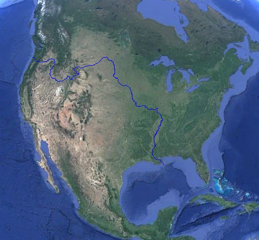
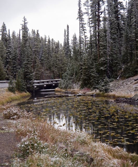
There's a natural spring in Yellowstone National Park in Wyoming that flows in 2 directions. One ultimately connects to the Mississippi River, which flows into the Gulf of Mexico. The other connects to the Columbia River, which flows into the Pacific Ocean. It's a natural wonder called the Parting of the Waters.
You can reach the spot after a 15-mile hike from a trailhead in the park. A sign points to the flow of both oceans.
But there's more! The Parting of the Waters isn't the only water connection in the United States between the Atlantic and the Pacific. Just a few miles away is Isa Lake, which also divides its two outlets between the Atlantic and Pacific Oceans. But Isa Lake does it backwards. The western outlet loops around and flows to the Gulf of Mexico. The eastern outlet also loops around and heads toward the Pacific.

What Lurks in Your Drinking Water

A careless teenager and a little urine was enough for Portland to flush 38 million gallons of otherwise clean water.

Tidal Power

Tidal power can do what wind and solar can’t: provide reliable energy, right when you need it.

Machias Seal Island

An Ongoing Border Dispute Between the United States and Canada
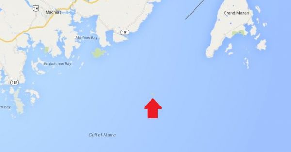
This is Machias Seal Island, a 20-acre island in the Bay of Fundy.
You can't see it? Let's zoom in.
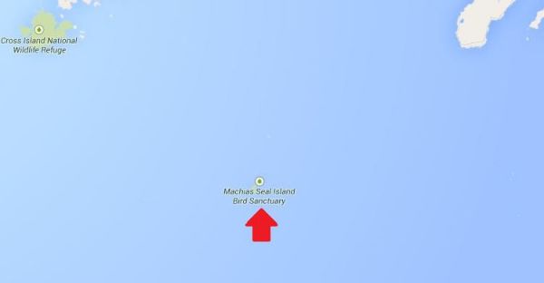
Hmm. That doesn't help much. Let's zoom in some more.
There it is! It's a speck of land that barely appears on the map.
You can see the lighthouse in the photo above. The island is inhabited by 2 human lighthouse keepers, a few seals...
...and lots and lots of puffins.
The ownership of Machias Seal Island is disputed by the United States and Canada. Canada is in physical possession of it, but the United States has not formally dropped its claim to the island.
We've previously written several posts about the development of the US-Canadian border, which includes weird exclaves. Ambiguity about the border even led to the creation of 2 short-lived nations.
(Painting by Benjamin West of the American delegation at the Treaty of Paris)
Although the United States and Canada now maintain a long, peaceful border, the placement of that border has been in doubt since the Treaty of Paris (1783) in which Britain recognized the United States as an independent nation. That treaty attempted to draw borders over unexplored lands. The authors did the best that they could with their knowledge of geography. But, alas, one of the descriptions for the border between Maine and maritime Canada was problematic. The treaty says that US territory includes:
all Islands within twenty Leagues of any Part of the Shores of the United States, and lying between Lines to be drawn due East from the Points where the aforesaid Boundaries between Nova Scotia on the one Part and East Florida on the other shall, respectively, touch the Bay of Fundy and the Atlantic Ocean, excepting such Islands as now are or heretofore have been within the limits of the said Province of Nova Scotia.
IWeve bolded the parts of the text that are the source for the Machias Seal Island dispute.
As we've mentioned in a previous post, the eastern border of Maine was of great concern to the British. Some British officials coveted what Americans saw as their territory, and vice versa. Control of the Bay of Fundy was of great importance to British commissioners at the Treaty of Ghent (1814), which ended the War of 1812.
Now back to Machias Seal Island. The American argument is that it lies within 20 leagues (approximately 69 miles) of the coast of the United States.
The Canadian argument is that a land grant that pre-exists the Treaty of Paris defines the island as part of Nova Scotia. It built and has operated a lighthouse on the island since 1832.
Occasionally fishermen from the 2 nations have gotten into scraps about its ownership. Some Canadian citizens have staked mining claims to the island as a means of asserting Canadian sovereignty. The State of Maine has included the island on its maps of electoral districts.
But if possession is indeed 9/10ths of the law, then Machias Seal Island is Canadian. The United States has chosen not to press the issue.

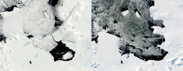
Massive iceberg six times the size of Manhattan drifts away from Antarctic glacier

 
This combination of Dec. 10, 2013, left, and March 11, 2014 photos provided by NASA shows a large iceberg separating from the Pine Island Glacier and traveling across Pine Island Bay in Antarctica. 
One of the largest icebergs on the planet, about six times the size of Manhattan, has separated from an Antarctic glacier and is floating out towards open ocean. The iceberg is named B-31, and is roughly 255 square miles (660 square km). Its estimated maximum thickness is 1,600 feet (487 meters). Last Fall, it broke off from the Pine Island Glacier. Researchers have been watching it drift away since then, via satellite.
"The ice island, named B31, will likely be swept up soon in the swift currents of the Southern Ocean, though it will be hard to track visually for the next six months as Antarctica heads into winter darkness," according to scientists at NASA's Earth Observatory monitoring its progress.
From Reuters:
NASA glaciologist Kelly Brunt said on Wednesday the iceberg covers about 255 square miles (660 square km) and is up to a third of a mile (500 meters) thick. Known as B31, the iceberg separated from Antarctica's Pine Island Glacier last November, Brunt added. "It's one that's large enough that it warrants monitoring," Brunt said in a telephone interview, noting that U.S. government organizations including the National Ice Center keep an eye on dozens of icebergs at any given time.
The iceberg isn't in the way of shipping lanes at this time. One of the funny things about this news story is how each news organization selects a different geographical entity to compare the iceberg's size to. CNN, based in Atlanta, chose Atlanta; AP chose Guam (Really? Guam?), Reuters chose NYC.
NASA time-lapse video below.

Coming Tomorrow

Coming Tomorrow
  • The Lost Empire That Ruled The Silk Road
  • Spain Launches Hunt For Quixote Writer Cervantes
  • The Oldest Known Selfie
  • Genomic Diversity Between Stone-Age Scandinavian Forgers And Farmers
And more ...
This hummingbird is our Animal Picture, for today.