Wednesday, May 21, 2014

The Daily Drift

Yeah, it's like that ...!
 
Carolina Naturally is read in 199 countries around the world daily.   

 Oh, waitress ... !
Today is  - National Wait Staff Day

Don't forget to visit our sister blog: It Is What It Is

Some of our reader today have been in:
The Americas
L'ancienne-Lorette, Joliette, Vancouver, Ottawa and Montreal, Canada
Salemburg, Lititz, Genesse, Pasadena and Manhattan, United States
Santiago, Chile
Bogota and Barranquilla, Colombia
Sao Paulo, Rio De Janeiro and Curitiba, Brazil
Tijuana, Mexico
Luquillo, Puerto Rico
Buenos Aries, Argentina
Europe
Bucharest and Galati, Romania
Oberhausen, Wiesbaden, Munchweiler An Der Rodable, Nuremberg, Frankfurt Am Main, Dresden, Berlin, Rothe Erde and Hamburg, Germany
Giresun, Afyonkarahisar and Istanbul, Turkey
London, Cambridge, Slough, Maidenhead and Pool, England
Bologna, Ivrea, Due Carrare, Rome and Ravenna, Italy
Valbo and Kista, Sweden
Lyon, Salon-DE-Provence, Rouen and Paris, France
Granada, Madrid and Algeciras, Spain
Stenlille and Arhus, Denmark
Ryazan, Moscow, Vladivostok and Mosrentgen, Russia
Donets'k and Vinnytsya, Ukraine
Reykjavik, Iceland
Warsaw, Poland
Dublin And Limerick, Ireland
Dubrovnik, Croatia
Yerevan, Armenia
Sarajevo, Bosnia and Herzegovina
Kaunas, Lithuania
Bratislava, Slovakia
Arendal, Norway
Asia
Mumbai, Noida, Kolkata, Sri Karanpur, Thiruvananthpuram, Shillong and Suratgarh, India
Colombo, Sri Lanka
Doha, Qatar
Riyadh, Saudi, Arabia
Al Haritah and Bayji, Iraq
Seri Kembangan, Kuala Lumpur and Alor Setar, Malaysia
Islamabad, Pakistan
Bangkok, Thailand
La Dagotiere, Mauritius
Dubai, United Arab Emirates
Hanoi, Vietnam
Taipei, Taiwan
Jakarta, Indonesia
Tehran, Iran
Africa 
Lome, Togo
Cape Town and Johannesburg, South Africa
Al Jizh, Egypt
Algiers, Algeria
The Pacific
Sydney, Australia
Auckland, New Zealand

Today in History

996 Sixteen year old Otto III is crowned the Roman Emperor.
1471 King Henry VI is killed in the Tower of London. Edward IV takes the throne.
1506 Christopher Columbus dies.
1536 The Reformation is officially adopted in Geneva, Switzerland.
1620 Present-day Martha's Vineyard is first sighted by Captain Bartholomew Gosnold.
1790 Paris is divided into 48 zones.
1832 The Democratic party holds its first national convention.
1856 Lawrence, Kansas is captured and sacked by pro-slavery forces.
1863 The siege of the Confederate Port Hudson, Louisiana, begins.
1881 The American Red Cross is founded by Clara Barton.
1927 Charles Lindbergh lands in Paris completing the first solo air crossing of the Atlantic.
1940 British forces attack German General Rommel's 7th Panzer Division at Arras, slowing his blitzkrieg of France.
1941 The first U.S. ship, the S.S. Robin Moor, is sunk by a U-boat.
1951 The U.S. Eighth Army counterattacks to drive the Communist Chinese and North Koreans out of South Korea.
1961 Governor Patterson declares martial law in Montgomery, Alabama.
1970 The U.S. National Guard mobilizes to quell disturbances at Ohio State University.
1991 In Madras, India, a suicide bomber kills the former Prime Minister, Rajiv Gandhi.

Kana:takon

A Tiny Piece of Canada Attached to the United States

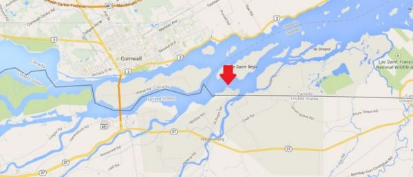
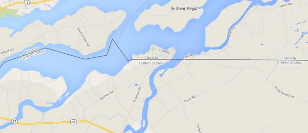
Pictured above is the border between the United States and Canada. To the south, you see the State of New York. To the north, you see the provinces of Quebec and Ontario. You'll notice that there's a slice of land north of the border that is not attached by land to Canada. Let's take a closer look.
This exclave is called Kana:takon. It's less than a square mile in area. The story of how it ended up Canadian instead of American goes back to the 1783 Treaty of Paris, the first attempt to define the boundaries of the nascent United States of America. That treaty's lengthy description of the border said that this area would be divided by the middle of the St. Lawrence River to the 45°N line of latitude.
These were decisions made by people with limited knowledge of the actual geography and, by modern standards, inadequate surveying equipment. As I've mentioned previously, such problems led the United States to accidentally build a fort in Canada.
The Great Lakes and the St. Lawrence River have numerous islands. It was not always clear from the Treaty of Paris which islands belonged to which nation. But boundary commissions worked during the 1830s and resolved the outstanding issues by the 1842 Webster-Ashburton Treaty. St. Regis, as Kana:takon was known at the time, would remain Canadian.
The entire territory is part of a Mohawk Native American/First Nations community that straddles the US-Canadian border. Members of that nation cross the international border freely because the 1794 Jay Treaty permits them to do so:
It is agreed that it shall at all Times be free to His Majesty's Subjects, and to the Citizens of the United States, and also to the Indians dwelling on either side of the said Boundary Line freely to pass and repass by Land, or Inland Navigation, into the respective Territories and Countries of the Two Parties on the Continent of America (the Country within the Limits of the Hudson's Bay Company only excepted) and to navigate all the Lakes, Rivers, and waters thereof, and freely to carry on trade and commerce with each other.

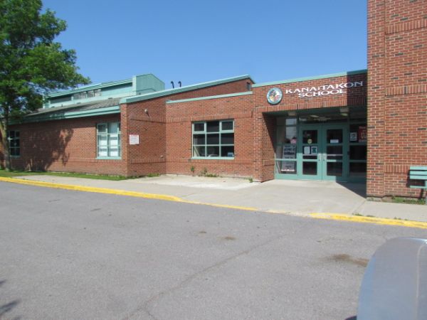
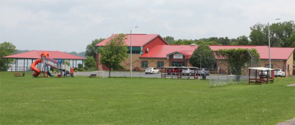
Kana:takon is a thriving community with its own school, homes, and businesses. It's easy to walk or drive into the United States. But though it's part of Canada, residents must drive through the United States to get to Canada.

For Sale: Dracula's Castle

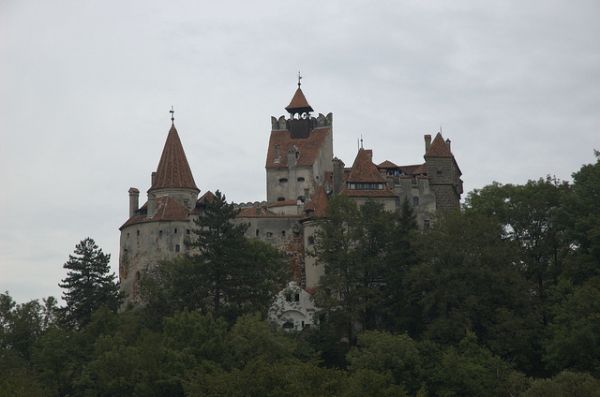
Now's your chance to buy a stake in Dracula's castle! Bran Castle in Romania, which has existed in various forms since the Thirteenth Century, is for sale. Prince Vlad the Impaler (1431-c.1476), the source of the Dracula legend, was imprisoned there for two months.
Much later, Bran Castle was the property of the Romanian royal family. In 1948, the royal family was stripped of its property and driven out of the country. After the collapse of the Ceausescu regime, Romania returned the castle to members of the royal family. Those three property holders are now elderly and would like to turn Bran Castle over to someone else. Mark Meyer, a representative of the sellers, described the possible future of the castle:
“Archduke Dominic and his family care very much for the castle, and it’s in far better shape now than it was when run by the government,” says Meyer. “The aim, though, is to take the whole thing a stage further, re-route the road and make Bran a destination, the kind of place people will stay for two or three days.”
There’s enough land to build a small hotel, he adds. “And we’re also installing a glass elevator that will lead to a tunnel in the mountain, with a light show featuring Dracula and the whole history of the place.
“That’s why we’d like whoever buys the castle to continue running it as a tourist destination. This isn’t just a national monument, it’s the largest and most significant attraction in Romania.”
Would you like to live in Dracula's castle?

A 600-Year Old Tower in Front of a Modern Skyscraper

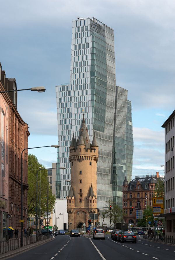
This is Frankfurt, Germany. The Eschenheimer Turm is the shorter of the two towers that you see in the center of this photo. Upon its completion in 1428, this tower was a strongpoint in the city’s defensive plan. It’s 154 feet high and has 10 accessible levels. The tower was originally part of a broad wall. Builders placed a portcullis in it to make entrance into the inner city defensible.
It’s now a restaurant.
Behind the Eschenheimer Turm is the Nextower, a 446-foot tall office building built in 2009. As far as I can determine, it does not have a portcullis.
That seems like a major oversight.

The Beautiful Town Of Garmisch-Partenkirchen In Germany

In 1936, the German towns of Garmisch and Partenkirchen were joined together to create more hotel rooms for the 1936 Winter Olympics. The town is located at the base of the Zugspitze, the country's tallest mountain that reaches high more than 9,000 feet, making it perfect for skiing and for other winter sports.

Even though Garmisch-Partenkirchen has been combined for years, you can still see the distinct differences between the two with Garmisch's modern look and Partenkirchen's fresco-filled, cobblestone streets. Despite the differences, the town as a whole is truly one of Germany's majestic must-sees.

Haunted Forests

Haunted forests of Dartmoor National Park in Devon, England

Disaster Warning: The Area Under The Keystone XL Pipeline Is Likely To Experience Earthquakes

The area geologists warned is likely to experience damaging earthquakes is situated under the proposed path of the KeystoneXL pipeline set to carry bitumen-laden tar sand renowned for…
Oklahoma_equakes-1
It is always humorous to California residents to hear relatives and friends from out of state say they are never visiting California because they are terrified of earthquakes; particularly those living in the Southwestern region of the country that is regularly devastated by extreme weather events such as tornadoes, droughts, and floods. It is true that an earthquake can be a frightening event, but no more so than the annual round of tornadoes in the so-called “tornado alley” region in states such as Oklahoma. It is not uncommon for Americans living in the tornado alley region to say they would rather be terrified of tornadoes and flash floods than earthquakes in California, but now they should be more terrified of increasingly common Oklahoma earthquakes than the occasional California tremors to accompany their fear of extreme weather events.
Last week the U.S. Geological Survey (USGS) and Oklahoma Geological Survey (OGS) issued an advisory warning of an increased likelihood of “damaging earthquakes” as a result of the increased number of small and moderate shocks in central and north-central Oklahoma. Both the USGS and OGS reported that there have been a stunning 183 earthquakes of magnitude 3.0 and greater in the Sooner state between October 2013 and April 2014. The two agencies issued the warning advisory because the increase in the rate of earthquakes above 3.0 on the Richter Scale since last October increases the possibility of a “damaging” quake of 5.0 magnitude or higher in central Oklahoma as a result of injecting chemical-laden water used in hydraulic fracturing (fracking) of tight rock formations to “fracture” rock deep underground to extract oil and gas.
To get an idea of the inordinate increase is seismic activity in Oklahoma due to fracking, the long-term average between 1978 and 2008 was about two 3.0 magnitude earthquakes per year. In the past 24 hours there were 5 significant (2.5 magnitude or greater) quakes that accounted for 13% of the quakes worldwide. Oklahoma experienced more earthquakes in 2014 than tremor-prone California that is also well over twice the size of Oklahoma. In the jointly-issued warning advisory, geologists identified the culprit as oil industry wastewater injected into deep geologic rock formations that increases underground pressure, lubricates faults, and causes earthquakes in a process geologists refer to as “injection-induced seismicity.” That is right; geologists have named the cause of the earthquakes that are the result of hydraulic fracturing, or “fracking.”
Geologists have noted that the recent Oklahoma earthquake rate changes are unrelated to typical random fluctuations in natural seismicity rates. The area geologists warned is likely to experience damaging earthquakes is situated under the proposed path of the KeystoneXL pipeline set to carry bitumen-laden tar sand renowned for ruptures without earthquakes, but that is something Republicans beholden to the oil export industry are unlikely to ever admit. In fact, the oil industry will not admit fracking has any relationship to increased earthquake activity in any region much less Oklahoma.
The oil industry claims, like BP after pouring 210 million gallons of crude oil into the Gulf of Mexico and along America’s Gulf Coast, it is unfair to blame the uncharacteristically large number of earthquakes on anything the industry is doing.  According to the vice president of regulatory affairs for the Oklahoma Independent Petroleum Association, Brian Woodward, “Granted, we’ve not seen this level of seismic activity in Oklahoma in the last 60 to 80 years and before that we don’t have a record. It causes us all concern, but the rush to correlate this activity with our industry is something we don’t believe is necessarily fair.” All that remains is for some oil industry-funded repugican to issue a heartfelt apology to the oil industry on the floor of the House or Senate for geologists and geophysicists blaming the uncharacteristically high number of earthquakes in Oklahoma on fracking. After the repugicans apologize, there will be a Koch Industry-funded campaign to discredit geologists and geophysicists as perpetrating a United Nations hoax to destroy the American fracking industry.
Researchers have long known that high-pressure fluid-injection operations (fracking) can trigger earthquakes, and in central Oklahoma a cluster of four high-volume wastewater injection wells triggered quakes up to 30 miles away, according to Katie Keranen a geophysicist at Cornell University in New York. Keranen said, “These are some of the biggest wells in the state, and the pressure is high enough from the injected fluids to trigger earthquakes that have since spread farther outward, as fluids migrate farther from the massive injection wells.” Fracking has already been linked to Oklahoma’s strongest recorded quake in 2011, as well as a spate of more than 180 smaller tremors in Texas between Oct. 30, 2008, and May 31, 2009.
In California, a state notorious for its labyrinth of serious seismic faults is heading into early days of an extreme drought unseen in well over 500 years, so repugicans and the oil industry are waging a ferocious battle to stop a moratorium on fracking. Besides increasing the risk of very substantial earthquakes from fracturing deep rock formations, the oil industry is taking what little precious water the state has for agriculture and drinking and mixing it with toxic chemicals and injecting it into the ground directly over fault lines up and down the state. The oil industry and repugicans are particularly anxious to increase fracking along California’s pristine coast and Central Valley that produces a large percentage of the nation’s food source. Both areas are two of the hardest hit by the epic drought that has officials considering rationing water for consumer use, not to mention the state’s agriculture industry that is already paying dearly for what precious little water the state’s reservoirs have left.
The practice of fracking is nearly free of regulatory oversight due in large part to repugicans protecting the oil industry despite the increased frequency of earthquakes in areas virtually unknown for seismic activity. Also related to fracking is a strong correlation between proximity to fracking wells and congenital heart defects in newborns. According to a study in Colorado, as the number and nearness of wells to a pregnant woman’s home went up, so did the likelihood her newborn would develop a heart problem. The study found that, “Births to mothers in the most exposed tertile [an exposure level equal to 125 wells within mile of the home] had a 30% greater prevalence of CHDs [congenital heart defects]…than births to mothers with no wells within a 10-mile radius of their residence.” Another study in Pennsylvania found that “proximity to fracking increased the likelihood of low birth weight by more than half, from about 5.6 percent to more than 9 percent. The chances of a low Apgar score, a summary measure of the health of newborn children, roughly doubled, to more than 5 percent.” Naturally, pro-fracking advocates scoffed at both studies and told mothers “to ignore the reports and not to rely on these studies as an explanation of why one of their children might have had a birth defect.”
As it turns out, Oklahoma residents should not fear coming to California whatsoever. In fact, Oklahoma is much more terrifying because although the Golden State has the occasional earthquake, it does not have Oklahoma’s yearly tornadoes or the level of fracking and earthquakes that prompted a warning from the USGS that the “big one” is on the horizon. Sadly for Oklahoma residents, there is little chance the repugican-controlled legislature or governor will take steps to limit fracking and reduce the threat of damaging earthquakes. Even though the oil industry and repugicans oppose a moratorium on fracking in California, the people care about their health, the environment, and their limited supply of drinking water and with a large Democratic majority in both houses of the legislature and governor’s office, the state’s biggest challenge is not fracking-induced earthquakes; just a severe drought.

Elephant Rock

Fresh reports of vandalism of ancient rock art in Western Australia

Rock art in Western Australia's Pilbara region believed to be up to 60,000 years old has been attacked by vandals.
Ancient rock art in Murujuga National Park on the Burrup Peninsula has been defaced by vandals
Tourist guide and Ngarluma man Clinton Walker said he had discovered a defaced piece of rock art on the Burrup Peninsula in Murujuga National Park.
"Someone has actually etched into a rock right above where some of the rock art is and wrote: 'go and work for a living'," he said.
The Burrup Peninsula is home to the world's biggest collection of Aboriginal rock art and gained national heritage listing in 2007.
Greens MP Robin Chapple said he was shocked and disappointed to learn of the fresh vandalism reports.
Mr Chapple said textas and spray paints had also been used to deface the art.
"There's people spray painting their names on rocks around the Burrup," he said.
"A group of international visitors used a texta to write their names and the date and everything else on the rock art."
Mr Chapple said vandalism and graffiti on the rocks was unacceptable and more needed to be done to educate people about just how precious the art is.
"Vandalism is probably the most detrimental thing that can happen in the short-term," he said.
"Those scratches aren't going to go away because exactly the same way that the carvings remain, those scratches remain.
"So, whoever's done the vandalism out there has left their signature there for a very, very long time."
Vandalism of rock art 'a hobby'
Mr Chapple said he was also aware of vandalism in other areas.
"We know that also on the Yabura Trail, just behind Karratha, there's also rock art that's being defaced," he said.
"It seems to be a hobby or fun for some people to go around literally desecrating what is the world's most important Mona Lisa."
He said the estimated two million carvings on the Burrup Peninsula and in the Dampier Archipelago are of global value.
"What we have here is the largest gallery of rock art anywhere in the world, the oldest gallery of rock art anywhere in the world and the only gallery of rock art anywhere in the world that actually shows the continuing in-habitation of an area and the changes to society over the last 30,000 years," he said.
"It is the only area of the world that has anything like this."
Mr Walker said the graffiti was upsetting and more needed to be more done to educate tourists about just how sacred the sites were to traditional owners.
"It's not just Aboriginal rock art, it's now Australian art," he said.
"We all live in the same place, share the same place, we need to all protect it to make sure it's there for future generations."
Last year the Murujuga National Park was declared a national park in an effort to conserve the area, but the move was criticized by the Friends of Rock Art group who said it fell far short of protecting the Burrup's significant cultural heritage.
They said the park would only cover 44 per cent of the peninsula, leaving the rest open to future industrial expansion.
Researchers from the Australian National University believe the art could be up to 60,000 years old.
There is maximum fine of $20,000 under WA law if a person is found to have defaced rock art.

Huge artificial desert created after scheme to build city lake went awry

A Chinese city has created a huge artificial desert on its outskirts after a scheme to create a nature park went badly awry. The idea was for a beautiful lake to be built on the outskirts of Zhengzhou City in Henan Province in central China. In order to create it developers had to tap a natural water source as well as removing hundreds of thousands of tons of sand to make the hole. But nature did not play along with the plans. The underground water source dried up and the sand began to spread, creating a wasteland of parched and arid earth instead of the green landscape that its creators had in mind.

Other vegetation in the area began to be choked by the drifting sand until all that remained was a Saharan look-a-like. "It is a triumph of central planning where everything that could have gone wrong did," said Sun-Yat Foo. The artificial desert is not far from the thriving business district of the city, and on windy days, the sand is carried into the center where it forces pedestrians to wear face masks in order to breathe.
"The pile of sand is now 100 feet high in some places. The local government does not take any protective measures for it at all. During a recent holiday high wind brought flying dust and sand, making it hard for us to open our eyes when we're outdoors. No-one wants to do business around here with this desert on their doorstep," a commercial tenant nearby said sadly.

The Science Behind Yellowstone's Rainbow Hot Spring

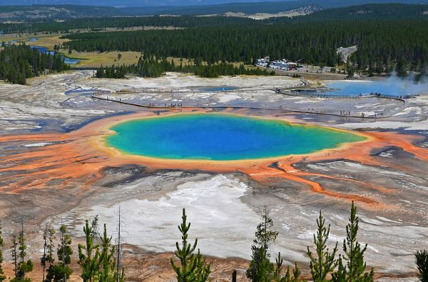
The Grand Prismatic Spring at Yellowstone National Park is so colorful that it’s hard to believe there aren't dyes or Photoshop involved. But the formation is totally natural. The hot spring is one of many geysers and hot springs that vent the earth’s heat to the surface at Yellowstone. This one is full of water, and also full of different kinds of bacteria that give it those rainbow colors.
Water at the center of the spring, which bubbles up 121 feet from underground chambers, can reach temperatures around 189 degrees Fahrenheit, which makes it too hot to sustain most life (some life does manage to exist, but its limited to organisms that feed off of inorganic chemicals like hyrdogen gas). Because there's very little living in the center of the pool, the water looks extremely clear, and has a beautiful, deep-blue color (thanks to the scattering of blue wavelengths—the same reason oceans and lakes appear blue to the naked eye). But as the water spreads out and cools, it creates concentric circles of varying temperatures—like a stacking matryoshka doll, if each doll signified a different temperature. And these distinct temperature rings are key, because each ring creates a very different environment inhabited by different types of bacteria. And it's the different types of bacteria that give the spring its prismatic colors.
Smithsonian introduces us to the various types of bacteria that live in the different temperature zones, and tells us how each produces its distinctive color.

The Painted Hills In Oregon

You might be confused the first time you see these colorful hills. They are in Wheeler County, Oregon. It's a product of nature that has been through various geological eras, formed 35 million years ago. This was just a river plain that gradually sculpted and airbrushed into layers of ash filling the place with splashes of colors, thanks to ancient eruptions.

The hills beautifully shift from light colors to intense throughout the day, in different seasons, and in various sun angles. That's why this is a favorite not only among travelers but among photographers and artists as well.

The 8 Most Beautiful Water Landscapes In The World

When you first hear the word landscape, what comes to mind? Do you think of mountains, hills or the general countryside? In fact, landscape is more broadly defined as 'all the visible features of an area of land' which include bodies of water like rivers, lakes, ponds and the sea.

Here are 8 of the most beautiful water landscapes in the world. They're places that inspire us by not only making us want to travel, which taps into our adventurous spirit, they're places that make us want to live a better, more meaningful and fulfilling life.

Mystery Seagrass Circles In Croatia Puzzle Experts

You've heard about crop circles, but what about seagrass circles? Aerial photos of the coastline of several islands in Croatia show regular circles of sand amidst a sea of Posidonia oceanica, a seagrass endemic to the Mediterranean.

Biologist Mosor Prvan from the Sunce Association, a nonprofit environmental organization that first noticed the circles, doesn't have an explanation for the phenomenon. The circles are about 164 feet in diameter and are roughly at the same distance from the islands and from one another.

Can the Solar Wind Trigger Thunderstorms?

After studying the correlation between space weather enhancements and thunderstorms in the UK, scientists think they've found a link.

Hurricanes on the Move!

Hurricanes and typhoons are migrating from the tropics toward the North and South poles, a new study finds.

See the US With an Ocean That's 10-Feet Higher

A new map displays the effect of a 10-foot sea-level rise on U.S. coastal areas. Spoiler alert: Miami and Boston do not look good.

Hidden Greenland Valleys Up Glacier Melting Risk

The discovery of deep fjords means that the worst-case scenarios for melting ice need to be revised.

New Underwater Volcano Discovered in Hawaii

A newly discovered underwater peak, called Ka'ena volcano, brings Oahu island's volcano count to three, up from two. 

West Antarctic Ice Sheet Has Begun to Collapse

The West Antarctic ice sheet has long been considered at risk due to global warming, and today, two studies report, the melting has begun.

5 Myths About Antarctic Melt

Here's the reality behind some common misconceptions about big changes in Antarctica.

Fossils Reveal Post-Asteroid Cold Snap Doomed Dinosaurs

Fossil matter proves that the Earth cooled suddenly after an asteroid impact thought responsible for killing the dinosaurs.

Coming Tomorrow

Coming Tomorrow
  • When everyone loved Poison Ivy
  • The last Queen of Hawaii
  • A brief history of soccer in the U.S.
  • Forgotten heroes who changed the course of American History
And more ...
This wolf is our Animal Picture, for today.