Cambridge
Bay, Nunavut, Canada, isn't the northernmost place mapped by Google
Street View, but it is one of the most inaccessible. There are no cars
there, just a few trucks. The citizens get around on snowmobiles, and
traffic in and out of the community of 1,477 people is by plane.
Everyone there know how to find their way around. But an Inuit
geographical-information-systems coordinator invited Street View to come
map the area anyway.
The Inuit man, Chris Kalluk,
said he approached Google with the idea of bringing Street View to the
Arctic last year as a way to educate the rest of the world about the
region. "People that have never been in the North, past trees, in
communities you can only get to by airplanes; they just don't know,"
Kalluk said by telephone from Cambridge Bay, where he has lived most of
his life.
"They wonder if we live in igloos and travel by dog
team. I spoke with an elder the other day who said that the land belongs
to all the people, so everyone should be able to see it."
Fishing
and hunting trips, often covering long distances, remain an important
part of life for the Inuit in Cambridge Bay, or Ikaluktutiak as it's
known in the native Inuinnaqtun language. But because magnetic compasses
do not work in the far north, paper maps were rarely used for
navigation in the past.
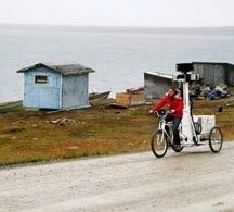
So Street View went to
Cambridge Bay, and Google geostrategist Karin Tuxen-Bettman photographed
the area with cameras mounted on a human-powered tricycle. Local kids
followed on their own bikes. In just a few months, we will all be able
to see the village up close.
More

No comments:
Post a Comment