Wednesday, May 7, 2014

The Daily Drift

Ahem ...!
 
Carolina Naturally is read in 199 countries around the world daily.   

Go Ride A Bike ... !
Today is - Bike To School Day

Don't forget to visit our sister blog: It Is What It Is

We would like to welcome our newest readers in:
Samoa 


Some of our reader today have been in:
The Americas
Pikangikum, L;ancienne-Lorette, Thunder Bay, Sioux Lookout, Joliette, Ottawa, Lansing, Saint John's, Britannia, Toronto, Downsview, Lake Louise and Nunalla, Canada
Fredonnia, Buckhannon, Lititz, Butte, Valrico, Bozeman, Molalla, Cerritos, Alamogordo, Cleburne, Waxhaw, Wichita and Sebring, United States
Luquillo, san Juan, Puerto Rico
Sao Paulo, and Rio De Janeiro, Brazil
Mexico City, Mexico
Buenos Aires, Argentina
Bogota and Medellin, Colombia
Tipitapa and Managua, Nicaragua
Puerto Plata, Dominican Republic
Lima, Peru
Europe
Riga, Latvia
Zagreb, Croatia
Algeciras, Madrid and Cadiz, Spain
Rome, Ivrea and Novara, Italy
Dublin and Cork, Ireland
Deville-Les-Rouen, Gasny and Salon-De-Provence, France
Bucharest, Romania
Slagelse, Denmark
Kent and London, England
Ruse, Bulgaria
Nuremberg, Widdern and Frankfurt Am Main, Germany
Athens, Greece
Naaldwijk, Netherlands
Cherskasy and Zhovtivody, Ukraine
Oslo, Norway
Belgrade, Serbia
Vantaa, Finland
Reykjavik, Iceland
Ryazan, Russia
Sarajevo, Bosnia and Herzegovina
Warsaw and Poznan, Poland
Asia
Sai Buri and Bangkok, Thailand
Colombo, Sri Lanka
Dhahran, Saudi Arabia
Tehran, Tabriz, Iran
Mumbai, Noida, Hyderabad, Chandigarh, Gurdaha, Delhi, Shillong, Thiruvananthpuram, New Delhi, Patna, Kolkata and Bangalore, India
Tel Aviv, Israel
La Dagotiere, Mauritius
Hanoi, Vietnam
Kuching and Kuala Lumpur,  Malaysia
Muscat, Oman
Yogyakarta and Jakarta, Indonesia
Kathmandu and Banepa, Nepal
Karachi, Pakistan
Africa 
Osogbo, Nigeria
Zarzis and Tunis, Tunisia
Johannesburg, South Africa
Nairobi, Kenya
The Pacific
Apia, Samoa
Makati and San Pablo, Philippines
Melbourne and Sydney, Australia

Today in History

558 The dome of the church of St. Sophia in Constantinople collapses. Its immediate rebuilding is ordered by Justinian.
1274 The Second Council of Lyons opens in France to regulate the election of the pope.
1429 Joan of Arc breaks the English siege of Orleans.
1525 The German peasants' revolt is crushed by the ruling class and church.
1763 Indian chief Pontiac begins his attack on a British fort in present-day Detroit, Michigan.
1800 Congress divides the Northwest Territory into two parts. The western part will becomes the Indiana Territory and the eastern section remains the Northwest Territory.
1824 Beethoven's "Ninth Symphony" premiers in Vienna.
1847 The American Medical Association is formed in Philadelphia.
1862 Confederate troops strike Union troops at the Battle of Eltham's Landing in Virginia.
1864 The Battle of Wilderness ends with heavy losses to both sides.
1877 Indian chief Sitting Bull enters Canada with a trail of Indians after the Battle of Little Big Horn.
1915 The German submarine U-20 torpedoes the passenger ship Lusitiania, sinking her in 21 minutes with 1,978 people on board.
1937 The German Condor Legion arrives in Spain to assist Fransico Franco's forces.
1942 In the Battle of the Coral Sea, Japanese and American navies attack each other with carrier-launched warplanes. It is the first time in the history of naval warfare where two fleets fought without seeing each other.Two crucial battles in 1942 marked the turning point of the war in the Pacific.
1943 The last major German strongholds in North Africa–Tunis and Bizerte–fall to Allied forces.
1945 Germany signs an unconditional surrender, effectively ending World War II in Europe.
1952 In Korea, Communist POWs at Koje-do riot against their American captors.
1954 French troops surrender to the Vietminh at Dien Bien Phu.
1958 Howard Johnson sets an aircraft altitude record in F-104.
1960 Leonid Brezhnev becomes president of the Soviet Union.

Why did Russia give away Crimea in the first place?


Good question.  Discussed at length at the website of the Wilson Center:
Crimea was part of Russia from 1783, when the Tsarist Empire annexed it a decade after defeating Ottoman forces in the Battle of Kozludzha, until 1954, when the Soviet government transferred Crimea from the Russian Soviet Federation of Socialist Republics (RSFSR) to the Ukrainian Soviet Socialist Republic (UkrSSR)...

Of particular importance were the role of Nikita Khrushchev, the recent traumas inflicted on Ukraine, and the ongoing power struggle in the USSR... Khrushchev saw the transfer as a way of fortifying and perpetuating Soviet control over Ukraine now that the civil war had finally been won. Some 860,000 ethnic Russians would be joining the already large Russian minority in Ukraine...

The transfer of Crimea to the UkrSSR also was politically useful for Khrushchev as he sought to firm up the support he needed in his ongoing power struggle with Soviet Prime Minister Georgii Malenkov, who had initially emerged as the preeminent leader in the USSR in 1953 after Joseph Stalin’s death...

The earlier published documents, and materials that have emerged more recently, make clear that the transfer of Crimea from the RSFSR to the UkrSSR was carried out in accordance with the 1936 Soviet constitution... the main point to stress here is that it is incorrect to say (as some Russian commentators and government officials recently have) that Crimea was transferred unconstitutionally or illegally. The legal system in the Soviet Union was mostly a fiction, but the transfer did occur in accordance with the rules in effect at the time.
My excerpts probably don't do justice to the complexity of the arguments.  Those wishing to orate upon this at cocktail parties would do well to consult the source.

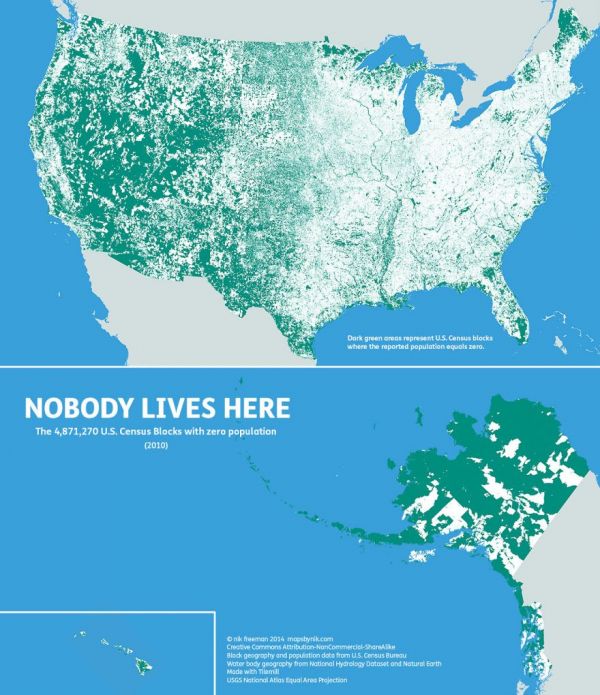
Nobody Lives Here

 
Nik Freeman made a map of the United States based on census data from 2010. The green parts are census blocks in which nobody lives. Keep in mind that a census block is not a fixed measurement, but a handy grid of locations for the census people to keep up with. You can see that some of the green areas are lakes, some are federal lands and parks, a lot of it is grazing land or desert, and some are just plain remote and hard to live in (Alaska). Green blocks may also be industrial areas and shopping centers, so “uninhabited” doesn’t always mean “undeveloped.” Commenters at Metafilter explained that much of the green in Maine is land owned by logging companies. The map, and a lot of information about its creation, are at mapsbynik.

The Town That Never Was

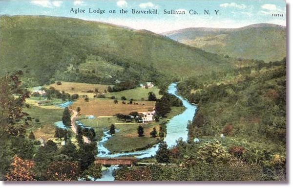
Agloe, New York


Last week, Google Maps took an entire town away. Wiped it off the map. Does Google have the power to do that? No, it was just correcting a mistake that has been copied and perpetuated for 90 years. The community of Agloe, in upstate New York, never really existed. It was placed on a 1925 map distributed by Socony gas stations as a copyright trap. Cartographers sometimes did that so they’d know if later maps were copied from theirs. Apparently the one with Algoe on it was copied a lot.
Among those countless copyright traps, Agloe achieved a rare distinction: The name stuck. As early as the 1930s, a fishing lodge named Agloe opened nearby (which later helped Rand McNally successfully claim in a lawsuit that the Agloe on its own map had not been copied from Socony’s).

Agloe survived on road maps by Esso and Exxon into the late 20th century and even long enough to evolve from a so-called paper town into a digital one on websites like Google, where it made its debut only last year.

It was even mentioned in a 1957 travelogue in The Times about “scenic drives through the Catskills,” which rhapsodized about “an unmarked country road that goes north through Rockland and Agloe.”
Google Maps only removed the town when a reporter from the New York Times asked about it. See, you don’t really have to visit a place to make a map of it… as long as you can read someone else’s map. The curious thing about Algoe is that it has been mapped so many times for so long that it has almost become real. Read about the history of Algoe, how it was named, and the fame that grew around the nonexistent town, at the New York Times.

It is one thing to lose your keys or your iPhone, even the love of your life, but to lose an entire town? Yet that is what just happened in upstate New York. Last week, Google did something it almost never does - it wiped a town off its maps. Don't blame Google. The town's provenance was suspect.

How Agloe, a speck of a hamlet in the western Catskills, wound up on maps 90 years ago remains a cartographic enigma. How it persevered is an existential riddle. In the 1930s, General Drafting Company founder Otto G. Lindberg and an assistant, Ernest Alpers, designed the town as a copyright trap.

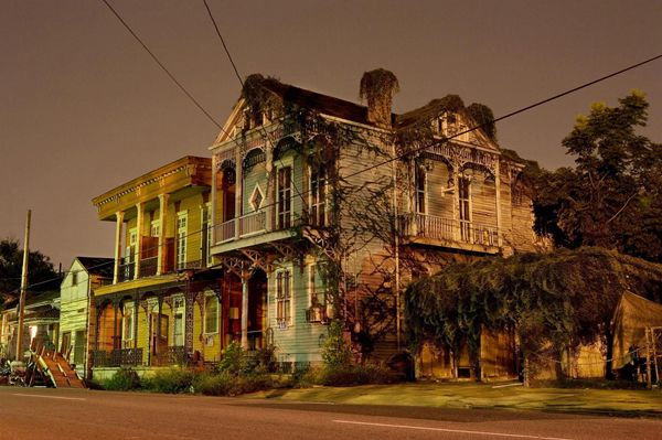
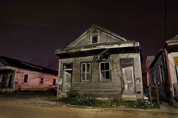
The Still Of The Night In New Orleans

New Orleans is a mysterious city full of dark folklore, a shadowy past, and yearly events full of drunken debauchery and things you cannot unsee, but for many the highlight of visiting the Big Easy is the city itself.
Boasting an extremely diverse range of architectural styles, from Creole cottages to shotgun houses and bungalows, New Orleans is a great place to take in the sights- especially in the still of the night.
Photographer Frank Relle rediscovered a deep love for his hometown of New Orleans after graduating college, so he decided to share his love of the Big Easy by taking long exposure nighttime photographs. They're eerie, visually compelling and full of unique charm- just like the City That Care Forgot.

How about this for a tiny home?

Moldhuset (literally “the earth/soil house”), a mountain cabin in Vikedal, Norway built by Ole Fatland.

The Surreal Appeal Of The Falkirk Wheel

Or how a remarkable piece of engineering bridges the eight story gap between two waterways. The only rotating boat lift of this type in the world, the Falkirk Wheel must be seen to be believed.

Frozen In Time

The Cyprus Buffer Zone

This year marks four decades since the Cyprus National Guard staged a coup that led to Turkish military intervention and escalated the civil war between the Greek and Turkish communities on the island. After the ceasefire, a heavily restricted buffer zone, controlled by the United Nations, was established between the north and south.
The demilitarized zone is restricted to the general public and no Greek or Turkish Cypriots are allowed inside. Reuters photographer Neil Hall recently visited the buffer zone, which still contains crumbling relics of times gone by - abandoned houses, businesses, and even an airport.

Archaeologists call for protection of Javanese megalithic site

Experts have called on the government to do more to protect the Gunung Padang archaeological site in Karyamukti village in Cianjur regency, West Java, where a prismatic structure considered to be older and larger than the Borobudur temple in Central Java is currently being excavated.
Gunung Padang site
According to several experts from the Gunung Padang independent and integrated research team (TTRM), the site could potentially be Indonesia’s oldest and most important prehistoric landmark and should be given priority in conservation efforts.
Indonesian Institute of Sciences (LIPI) researcher Danny Natawidjaja said that even without government support, excavation and conservation work would continue.
“We’ll foot the bill ourselves until everyone comes to their senses that this is a national asset,” said Danny at a discussion held by the Center for Information and Development Studies (CIDES) in Jakarta on Wednesday.
Ali Akbar, the head of the research team, revealed that US$25 million had been raised for the funding of the Gunung Padang project in 1979, a quarter of which came from the United Nations Educational, Scientific and Cultural Organization (UNESCO).
Ali said the project required experts from a variety of fields given its complexity.
“Discoveries like this only occur every other century,” said Ali.
Ali referred to the discovery of Borobudur temple as the last time such a historical heritage site was unearthed in the country.
He also called on the government to campaign to stop efforts to sell the location as a tourist destination.
“The site should be fenced off from the foot of the hill so that it can be protected,” said Ali, who is also the manager for research and community services at the University of Indonesia’s (UI) School of Humanities.
Ali said the structure covered the entire hill, and may possibly house man-made chambers deep within.
Danny, who spearheaded an exploration of the site in 2011, said that geological methods to determine the age of the site found that the structure could be older than any other discovered in the country.
“Using carbon dating, a method for calculating the age of a mineral, we found the first layer excavated to be between 2,500 to 3,600 years old, although the structure may have been built more recently than that,” said Danny.
He also said the site could be used to prove the nonlinear progression of human population growth.
In keeping with current beliefs, Danny suggested that primitive man would not have had the ability to build something as complex as Gunung Padang, yet the site could date back to a historical period when population growth and technological development were stagnant.
He insisted that there was a missing part to the solution that was worth researching.
Architecture expert Pon Purajatmika corroborated the claim by pointing out the use of a knowledge system in the construction of the site.
“Without the help of astronomy or knowledge about the surrounding area, the site could not have been built with such precision,” Pon revealed.
Pon suggested that Gunung Padang was not only a monotheistic site because of the absence of idolatry but that it was also built in orientation to the stars and the Sun.
He likened the construction of the megalithic site to the ruins of Machu Picchu in Peru, except that Gunung Padang predated the Incan site by some 2,000 years.
“The mountain is sloped on all sides, even symmetrical,” Pon told The Jakarta Post, adding that many relics were found within a radius of 5 kilometers, suggesting that the site used to be a hub of activity.
At the site’s information center, visitors are told that the terraced site was first recorded by Dutch researcher NJ Krom in 1914 before being rediscovered by local farmers in 1979.
Scientists have agreed to categorize the prismatic structure as a stepped pyramid that has an area of 3,094 square meters consisting of five levels. It stands more than 100 meters high and is believed to be the center of a 25-hectare megalithic site.
The geological structure of the stone onsite is meticulously layered and arranged by columnar jointing, with each stone varying in size.
Since 1985, only the top layer, which was considered to be a sacred ritual arena, has been fenced off by the government for preservation.
Previously, the West Java provincial administration called on the Cianjur regency administration and the local community to help protect the megalithic site, especially from vandalism, as well as to attract more tourists.

Sigiriya, An Ancient Magical Place

The ancient fortress of Sigiriya is among the most beautiful places on Earth. It is both an ancient fortress and a former palace. Also called the Lion's Rock, as it stands on top of a gigantic rock of 200 meters high, this amazing place is located in Matale District of Sri Lanka, surrounded by an extensive network of gardens, water tanks and other structures.

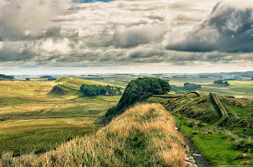
Hadrian's wall

The Romans buit this wall to keep the Picts from overrunning northern England - it didn't work.

The World's Best Skywalks

Do Look Down! 

As Canada's Glacier Skywalk opened this week, offering amazing views over Jasper National Park, here's a look at the best skywalks around the world.

Hike To The Wave, Arizona

Probably the most photographed landscape in Southwestern America, the Wave is a unique geological landform found in the Coyote Buttes ravine in the Vermillion Cliffs National Monument, Arizona.

Characterized by a dazzling sandstone rock with a surreal undulating appearance, the Wave looks like a scene from another planet. The striped Navajo Sandstone dates back 190 million years ago in the Jurassic Period, formed by slow erosion of wind and rain.

Totally Parched

California is parched, with 100 percent of the Golden State entrenched in drought conditions for the first time in 15 years, according to the U.S. Drought Monitor (USDM).

East Antarctica Melt Could Mean 10 Foot Sea-Level Rise

The melting of a small area of East Antarctica could lead to sea level rise for thousands of years. And halting global warming might not stop it.

Virginia Volcanoes Linked to East Atlantic Islands

The youngest volcanoes on the East Coast share an unusual geological link with islands on the opposite side of the Atlantic Ocean.

A Ride Around Etna

The Circumetnea Railway

If you don't have time to climb to Etna's summit, there are other options and one of them is to take the Circumetnea train. The railway was constructed between 1889 and 1895. The 110 kilometer (68.3 miles) line follows a route which almost encircles the Etna volcano.

Coming Tomorrow

Coming Tomorrow
  • Sybil Ludington
  • The Toilet That Sank The U-1206
  • Did da Vinci, Create A 3-D 'Mona Lisa'?
  • Ancient Native Americans Came Face To Face With Sabertooth Cats
And more ...
This colorful kingfisher is our Animal Picture, for today.