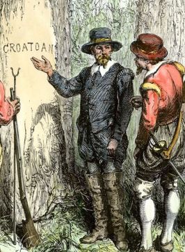
Sir
Walter Raleigh sponsored a colony of English immigrants on Roanoake
Island, on the Outer Banks of North Carolina. They arrived in 1587 and
had disappeared by 1590. It has since been called "The Lost Colony"
because no one knows what happened to the 90 men, 17 women, and 11
children who established the colony. They may had died from disease or
violence from Native Americans, or they may have left, possibly
splitting up to join tribal villages. In recent years, research into the
mystery was sparked by a discovery on a map drawn by the colony's
governor John White.
Two patches on the map made Brent
Lane of the First Colony Foundation (the group behind the latest
archaeological trip and a National Geographic grantee) in Durham, North
Carolina, wonder if they might hide something beneath.
Scientists
at the British Museum looked into the patches and discovered a tiny
red-and-blue symbol. Could it have indicated a fort or a secret
emergency location?
"Our best idea is that parts of Raleigh's
exploration in North America were a state secret, and the map 'cover-up'
was an effort to keep information from the public and from foreign
agents," said Eric Klingelhofer of Mercer University in Macon, Georgia, a
historian and the principal investigator on the project.
This
map point led researchers to take the latest technology out into the
area, ground-penetrating radar (GPR). The intriguing results present
evidence of a fort buried several feet under the ground. But what is
really underneath, and how old is it? It has been suggested that the
next step might be the use of a proton magnetometer. However, Clay
Swindell of the Museum of the Albemarle thinks they may have to resort
to old-fashioned research.
"We have to go in and dig some holes, I guess," Swindell said.
Read about the Lost Colony and
the latest research on its disappearance at NatGeo News.
 Sir
Walter Raleigh sponsored a colony of English immigrants on Roanoake
Island, on the Outer Banks of North Carolina. They arrived in 1587 and
had disappeared by 1590. It has since been called "The Lost Colony"
because no one knows what happened to the 90 men, 17 women, and 11
children who established the colony. They may had died from disease or
violence from Native Americans, or they may have left, possibly
splitting up to join tribal villages. In recent years, research into the
mystery was sparked by a discovery on a map drawn by the colony's
governor John White.
No comments:
Post a Comment