As
the Soviet Union was falling apart in 1989, Russell Guy bought a group
of crates from some military officers that turned out to be a treasure.
They were intricately-detailed maps of the world, created by Soviet
cartographers with the help of government spies.
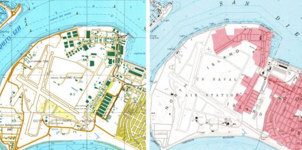
During
the Cold War, the Soviet military mapped the entire world, parts of it
down to the level of individual buildings. The Soviet maps of US and
European cities have details that aren’t on domestic maps made around
the same time, things like the precise width of roads, the load-bearing
capacity of bridges, and the types of factories. They’re the kinds of
things that would come in handy if you’re planning a tank invasion. Or
an occupation. Things that would be virtually impossible to find out
without eyes on the ground.
Given the technology of the time, the
Soviet maps are incredibly accurate. Even today, the US State
Department uses them (among other sources) to place international
boundary lines on official government maps.
The maps
are a storehouse of not only geography, but intelligence about the
places shown. Guy made a business out of them. But he wasn’t the only
one to come into possession of such maps. Others, such as John Davies,
have spent years studying them.
Read about these beautiful and detailed formerly secret maps at Wired.

No comments:
Post a Comment